|
St Francis |
|


South Pacific Weather Collection via SSB
July 2010
Here is what I ask for on pretty nearly a daily basis, while in French Polynesia trying to figure out the weather.
The 'send' are
the commands to get each product via Saildocs. See link at the bottom
for getting the same information via the internet. To request these
forecasts, use any email client and create an email with addressee request
att saildocs.com with Subject line beginning 'Saildocs Request' and with the
commands below in the body, one per line. You can request multiple
products in one email, but you will receive the responses back in separate
emails.
Fiji Met Surface Analysis
send fleet.nadi
send nadi.sopac
Each is about 2K in size.
The first one is known as the "Nadi Fleet Codes". With a proper viewer (a
program), this gives a synoptic picture of the weather systems between
French Poly and Australia.
You need a viewer to decode the Fleet Codes, and this turns the coded text
into a nice weather map. There are two programs floating around that are
viewers, WIAC and PhysPlot.
Download the Fleet Code program on the Pangolin website
www.pangolin.co.nz before you get out of internet range.
In my opinion, PhysPlot is easier to use, and also works on Windows 7. Below
is a screen shot from PhysPlot.
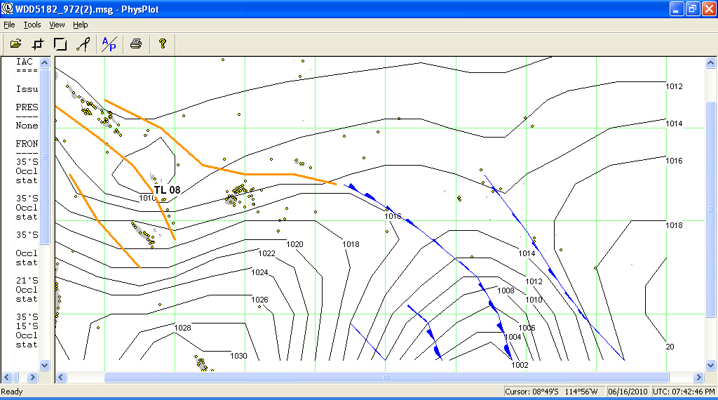
In PhysPlot, you can grab the slider bar and easily reveal the text describing the major weather features.
The second product is basically the same information, but is text. You have to
plot out the fronts and troughs yourself. Useful if you don't have the
viewer, but redundant, I think, once you get the fleet code viewer.
NOAA High Seas text forecast
This is for the area covering Fr Poly
westward, from
NOAA's Hawaii office. Coverage is EQUATOR TO 25S BETWEEN 120W AND 160E. Similar but sometimes different and sometimes
conflicting info for the same area. (about 2K in size)
send FZPS40.PHFO
NOAA Hawaii Weather Fax Products
SW Pacific Satellite Photo
Streamline Analysis
24, 48, 72 hr forecasts
| Freq's: 9980.6 11088.1 16133.1 USB |
| LOCAL | Product | Valid Time | Coverage |
| 0724 | SIGNIFICANT CLOUD FEATURES | 03/15 | 30S - 50N, 110W - 160E |
| 0755 | STREAMLINE ANALYSIS | 00/12 | 30S - 30N, 110W - 130E |
| 0849 | SW PACIFIC GOES IR SATELLITE IMAGE | 06/18 | 40S - 05N, 130W - 165E |
| 0940 | WIND/WAVE ANALYSIS | 00/12 | 30S - 30N, 110W - 130E |
| 0953 | 24HR WIND/WAVE FORECAST | 00/12 | 30S - 30N, 110W - 130E |
| 1302 | 48HR WIND/WAVE FORECAST | 00/12 | 30S - 30N, 110W - 130E |
| 1315 | 72HR WIND/WAVE FORECAST | 00/12 | 30S - 30N, 110W - 130E |
| 1341 | rebroadcast 24HR WIND/WAVE FORECAST | 00/12 | 30S - 30N, 110W - 130E |
| 1354 | STREAMLINE ANALYSIS | 06/18 | 30S - 30N, 110W - 130E |
| 1448 | SW PACIFIC GOES IR SATELLITE IMAGE | 00/12 | 40S - 05N, 130W - 165E |
| 1924 | SIGNIFICANT CLOUD FEATURES | 03/15 | 30S - 50N, 110W - 160E |
| 1955 | STREAMLINE ANALYSIS | 00/12 | 30S - 30N, 110W - 130E |
| 2049 | SW PACIFIC GOES IR SATELLITE IMAGE | 06/18 | 40S - 05N, 130W - 165E |
| 2140 | WIND/WAVE ANALYSIS | 00/12 | 30S - 30N, 110W - 130E |
| 2153 | 24HR WIND/WAVE FORECAST | 00/12 | 30S - 30N, 110W - 130E |
| 0102 | 48HR WIND/WAVE FORECAST | 00/12 | 30S - 30N, 110W - 130E |
| 0115 | 72HR WIND/WAVE FORECAST | 00/12 | 30S - 30N, 110W - 130E |
| 0141 | rebroadcast 24HR WIND/WAVE FORECAST | 00/12 | 30S - 30N, 110W - 130E |
| 0154 | STREAMLINE ANALYSIS | 06/18 | 30S - 30N, 110W - 130E |
I use Airmail's Getfax program with a PTC-2 modem to get weather fax. It already has the stations and frequencies coded in the program, and is pretty easy to use once you figure it out.
To receive fax well, you need to eliminate
all 'noise' onboard and connect to the proper frequency for the time of day
you are trying to get weather. A little experimentation before you
leave is useful! The worst noisemakers aboard are: 12v motors
(refrigeration!, fans), fluorescent lights, solar controllers, inverters &
computer chargers.
If you have a Sat phone, the 'Noaa Charts in Color from Hawaii' and one
Satellite photoa are within
reasonable download sizes. (see the
Internet Weather page)
French Poly Text Forecast (about 3k)
send fr.poly
It talks about French Polynesia in quadrants like A35. 'A' is 5-10 degrees S latitude, B is 10-15 degrees, C is 15-20 degrees, etc. The '35' is the area of longitude from 135-140, '40' is 140-145, etc. Most of the Tuamotus are in C40 and C45. Here's an example of the C40 forecast.
C40 - CENTRE TUAMOTU
SUR LA MOITIE NORD DE LA ZONE, VENT DE SECTEUR EST 07/10KT REVENANT A MI-ECHEANCE AU NORD-EST PUIS NORD A TERME.
SUR LA MOITIE SUD DE LA ZONE, SECTEUR NORD 07/10KT FRAICHISSANT A TERME 11/16KT. MER PEU AGITEE DEVENANT AGITEE A TERME SUR LA MOITIE SUD DE LA ZONE.
Obviously you need a translator. Download one here.
A picture of the French Poly weather zones can be downloaded from here.
Local detailed GRIB file (of course, this varies by location, about 15K)
send GFS:13S,19S,151W,143W|0.5,0.5|6,12..84|PRMSL,WIND,RAIN
Wide area GRIB file to see major patterns, (not detailed, about 15K)
GFS:07S,40S,170W,140W|3,3|6,12..168|PRMSL,WIND
You can add waves to the GRIB files by adding these two codes on the end: 'HTSGW,WVDIR'
but this will significantly increase the size of the file. When I want sea
state information, I usually just use the spot forecast. But understand that
the waves heights given are SWELL and not really wind-waves.
Spot forecast for my current anchorage (about 2K)
If you have this and aren't
moving, you can skip the first GRIB, about 2K. The lat/longs are in decimal degrees. This is extracted right out of the GRIB file, so has the same
errors that GRIB info can have
send spot:15.8S,146.1W|5,3
(Note that this can be requested using the grib file request window in
Airmail, use the button with the cross-hairs on it to set your location).
NZ Wefax
Freqs: 3247.4, 5807, 9459, 13550.5, 16340.1
The times & products applicable to the Tuamotus are as follows:
LOCAL TUAMOTU TIME (-10 UTC)
----------------------------
0600, 1200, 1800, 0000 - Surface Analysis
0200, 1400 - 36 hr forecast
0300, 1500 - 48 hr forecast
0400, 1600 - 72 hr forecast
Each product is broadcast at the top of the hour on 5807, then at 15 after
on 9459, at 30 after on 13550.5. At 45 after in the night hours, they use
3247.4, and in the afternoons 16340.1.
I used Getfax (download from the Airmail
site), and it has the freq's programmed in. Otherwise, use USB and subtract 1.9 off each
frequency to get the actual dial frequency. In French Poly, 5807 works best in the mornings,
higher frequencies in the afternoons (16 Mhz usually best for the afternoon
forecast sequence).
Other text forecasts for Further West
Click on the little box in the Airmail
toolbar just to the left of the GRIB request button with the blue center.
This should give you the list of available text forecasts. Expand the list
and look under Pacific and under that South, and there are a lot of other
forecasts you can request.
Bob McDavitt's Weathergram
Plus I also get Bob McDavitt's weathergram on Sunday (you can request this thru Saildocs or get a subscription sent to your Sailmail address through yotreps, on the Pangolin website). This is a weekly preview of the major weather systems between NZ and French Polynesia.